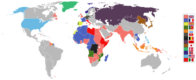
Plaetje:World 1936 empires colonies territory.png

Oearsprunkelik bestandj ((1.527 × 624 pixel, besjtandsgruutde: 44 kB, MIME type: image/png))
1936 coolio stuff
Besjrieving
العربية
English
മലയാളം
Deutsch
한국어
Українська
简体中文
繁體中文

|
Deze kaartafbeelding zou opnieuw moeten worden aangemaakt als een SVG-bestand door vectorafbeeldingen te gebruiken. Dit heeft een aantal voordelen; zie Commons:Media for cleanup voor meer informatie. Als er een SVG-formaat van deze afbeelding bestaat, dan deze graag uploaden. Nadat u dit heeft gedaan, gelieve dit sjabloon te vervangen door het sjabloon {{vector version available|nieuwe bestandsnaam.svg}} op deze afbeeldingspagina.
|

|
Wettelijke vrijwaring Dit beeld toont (of lijkt op) een symbool dat door de communistische regering van de Sovjet-Unie, communistische regeringen van andere landen in Europa of organisaties met hen verbonden werd gebruikt. Het gebruik van dit symbool kan onwettig zijn in Georgië, Hongarije, Indonesië, Letland, Litouwen, Oekraïne en Polen, afhankelijk van de context. In Hongarije is het wetboek van strafrecht 269/B.§ (1993) van toepassing. |

|
Wettelijke vrijwaring Dit beeld toont (of lijkt op) een symbool dat door de Nationale Socialistische (NSDAP/Nazi) regering van Duitsland of een gelieerde organisatie werd gebruikt, of een andere partij die door het Federale Constitutionele Hof van Duitsland is verboden. Het gebruik van insignia van organisaties die in Duitsland zijn verboden (als het Nazi hakenkruis of het pijlkruis) kan ook onwettig zijn in Duitsland, Oostenrijk, Hongarije, Frankrijk en andere landen, afhankelijk van de context. In Duitsland is paragraaf 86a van het wetboek van strafrecht van toepassing (StGB). |
See also
| Maps of world history | |
| BC | |
|
| |
| AD |
1 · 50 · 100 · 200 · 250 · 300 · 400 · 500 · 700 · 750 · 820 · 900 · 1200 · 1500 · 1556 · 1648 · 1700 · 1750 · 1815 · 1859 · 1871 · 1914 · 1989 · 2000 · |
|
Maps of colonization history | |
|
see also: Eastern Hemisphere only maps template (1300BC-1500AD) | |
| (this template: · view · discuss ) | |
.jpg)
._LOC_2001620596.jpg)
Licentie:

|
Toesteumming wert verleend veur t kopiëre, verspreide en/of wiezige van dit document onger de veurwaerd van de GNU-licentie veur vrieje documentatie, versie 1.2 of einige latere versie es gepubliceerd door de Free Software Foundation; zonger Invariant Sections, zonger Front-Cover Texts, en zonger Back-Cover Texts. n kopie van de licentie is opgenomme in de sectie GNU-licentie veur vrieje documentatie. |
| Dit bestandj steit gelicenseerdj óngere Creative Commons Attribution-Share Alike 3.0 Unported lisensje. | ||
| ||
| Dees licentie-tag woort tougevoeg aon dit bestand in verband mèt de GFDL licentie-update. |
Besjtandshistorie
Klik op 'ne datum/tied óm 't besjtand te zeen wie 't oetzaog op det tiedsjtip.
| Datum/Tied | Miniatuurplaetje | Aafmaetinge | Gebroeker | Kómmentaar | |
|---|---|---|---|---|---|
| hujig | 6 mei 2020 15:41 | 1.527 × 624 (44 kB) | The- | The Dominions should not be shaded in British Empire colour post-1931 Statute of Westmisnter. They had independent foreign policies and were no longer under British control in any way, shape or form. | |
| 12 mei 2019 14:34 | 1.527 × 624 (44 kB) | The- | If there are some problems with the accurate map, fix the accurate map, don't revert back to the old inaccurate map! | ||
| 12 sep 2018 09:34 |  | 1.458 × 627 (33 kB) | Oleksiy.golubov | Reverted to version as of 13:34, 29 July 2012 (UTC): no reason to indicate Turkey and China; colors of Belgium and the Netherlands were wrong. | |
| 20 jul 2018 21:51 | 1.527 × 624 (3,64 MB) | SuperSucker | oops forgot Germany had Nazi flag in 1936 | ||
| 20 jul 2018 21:39 | 1.527 × 624 (3,64 MB) | SuperSucker | fix - added Turkey (it existed as Turkey in 1936) and China; changed China's flag as they had it changed by 1930 | ||
| 20 aug 2016 16:47 | 1.527 × 624 (44 kB) | The- | Some fixes | ||
| 17 apr 2016 22:29 | 1.527 × 624 (44 kB) | The- | More accurate map | ||
| 29 jul 2012 15:34 |  | 1.458 × 627 (33 kB) | Faunas | Reverted to version as of 13:31, 29 July 2012 | |
| 29 jul 2012 15:33 |  | 1.458 × 627 (33 kB) | Faunas | In the previous version, São Tomé e Príncipe was indicated as a Spanish colony; I changed it to indicate it was a Portuguese colony (which it was). | |
| 29 jul 2012 15:31 |  | 1.458 × 627 (33 kB) | Faunas | In the previous version, São Tomé e Príncipe was indicated as a Spanish colony; I changed it to indicate it was a Portuguese colony (which it was). |
Plaetjesverwiezinge
Dit plaetje weurt op de volgende pazjena's gebroek:
Globaal besjtandjsgebroek
De volgende anger wiki's gebroeke dit bestandj:
- Gebroek in af.wikipedia.org
- Gebroek in am.wikipedia.org
- Gebroek in ar.wikipedia.org
- Gebroek in arz.wikipedia.org
- Gebroek in az.wikipedia.org
- Gebroek in bn.wikipedia.org
- Gebroek in bs.wikipedia.org
- Gebroek in de.wikipedia.org
- Gebroek in en.wikipedia.org
- Gebroek in fa.wikipedia.org
- Gebroek in fr.wikipedia.org
- Gebroek in ja.wikipedia.org
- Gebroek in lv.wikipedia.org
- Gebroek in mg.wikipedia.org
- Gebroek in ms.wikipedia.org
- Gebroek in nl.wikipedia.org
- Gebroek in pt.wikipedia.org
- Gebroek in sr.wikipedia.org
- Gebroek in th.wikipedia.org
- Gebroek in uk.wikipedia.org
- Gebroek in www.wikidata.org