Viking_expansion.png((507 × 310 pixel, besjtandsgruutde: 109 kB, MIME type: image/png))

Dit besjtandj kump van Wikimedia Commons en kin ouch in anger projekte gebroek waere. De pagina mit de besjtandjsbesjrieving wurt hiejónger weergegaeve.

(see en:File talk:Viking Expansion.svg)

Besjrieving

Besjrieving
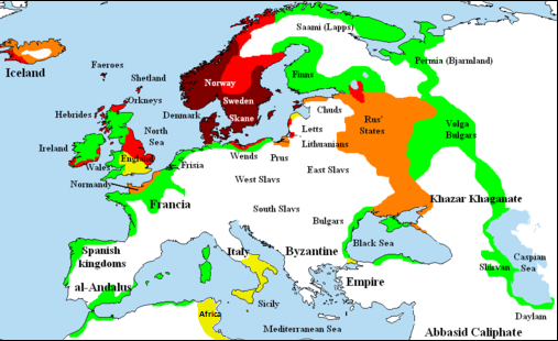
English: Map showing area of Scandinavian settlement (Vikings and Normans descendants from Normandy) in
 
eighth century
 
ninth century
 
tenth century
 
eleventh century
 
denotes areas subjected to frequent Scandinavian contacts, but with little or no Scandinavian settlement
Datum 14 november 2006 (originele uploaddatum)
Brón Briangotts (original uploader)
Sjriever Briangotts (original uploader)
Permissie
(Hergebroek van dit besjtandj)
Ich, de kopierechhaajer hievan, bring 't hiebie óngere vólgendje lisensje oet:
GNU head Toesteumming wert verleend veur t kopiëre, verspreide en/of wiezige van dit document onger de veurwaerd van de GNU-licentie veur vrieje documentatie, versie 1.2 of einige latere versie es gepubliceerd door de Free Software Foundation; zonger Invariant Sections, zonger Front-Cover Texts, en zonger Back-Cover Texts. n kopie van de licentie is opgenomme in de sectie GNU-licentie veur vrieje documentatie.
w:nl:Creative Commons
Attribuusje Deil gliek
Dit bestandj steit gelicenseerdj óngere Creative Commons Attribution-Share Alike 3.0 Unported lisensje.
De maags:
  • deile – aafsjrieve, verspreie en dórchgaeve
  • hèrminge – 't wèrk aanpasje
Óngere volgendje veurwaerj:
  • Attribuusje – Geer mótj op 'n gepasdje meneer 'n naamsvermeljing make, 'ne link nao de licentie opgaeve, en aangaeve of g'r 't werk verangerd höb. Geer moog dit op eder raejelike meneer doon, meh neet zoea det 't liek ofwen de licentiegaever instump mit eur werk of eur gebroek van zie werk.
  • Deil gliek – Went geer dit werk geremix, verangerd of doorverwirk höb, mótj geer 't verangerd matterjaal verspreie ónger dezelfde licentie wie 't oersjprunkelik werk, of 'n licentie die daomit samegeit.
Dees licentie-tag woort tougevoeg aon dit bestand in verband mèt de GFDL licentie-update.
De kens zelf de lisensje oetkeze.
Anger versies

[bewirk]

Bestand:Viking Expansion.svg is een vectorversie van dit bestand. Indien niet van slechtere kwaliteit dient deze gebruikt te worden in plaats van deze rasterafbeelding.

File:Viking expansion.png → File:Viking Expansion.svg

Zie Help:SVG voor meer informatie.

In andere talen
Alemannisch  Bahasa Indonesia  Bahasa Melayu  British English  català  čeština  dansk  Deutsch  eesti  English  español  Esperanto  euskara  français  Frysk  galego  hrvatski  Ido  italiano  lietuvių  magyar  Nederlands  norsk bokmål  norsk nynorsk  occitan  Plattdüütsch  polski  português  português do Brasil  română  Scots  sicilianu  slovenčina  slovenščina  suomi  svenska  Tiếng Việt  Türkçe  vèneto  Ελληνικά  беларуская (тарашкевіца)  български  македонски  нохчийн  русский  српски / srpski  татарча/tatarça  українська  ქართული  հայերեն  বাংলা  தமிழ்  മലയാളം  ไทย  한국어  日本語  简体中文  繁體中文  עברית  العربية  فارسی  +/−
SVG-bestand

Bijschriften

Beschrijf in één regel wat dit bestand voorstelt

Items getoond in dit bestand

beeldt af Nederlands

14 nov 2006

MIME-type Nederlands

image/png

Besjtandshistorie

Klik op 'ne datum/tied óm 't besjtand te zeen wie 't oetzaog op det tiedsjtip.

(nuujste | aadste) (nujer 10) () (10 | 20 | 50 | 100 | 250 | 500) bekieke.
Datum/TiedMiniatuurplaetjeAafmaetingeGebroekerKómmentaar
hujig26 fib 2018 00:58Miniatuurplaetje veur versie per 26 fib 2018 00:58507 × 310 (109 kB)AsmodimAdded the territory of the Norman "Kingdom of Africa (see the wikipedia article), conquests of the Norman kingdom of Sicily under Roger II
5 aug 2016 20:10Miniatuurplaetje veur versie per 5 aug 2016 20:10507 × 310 (109 kB)TheutatisExpanded area in Italy according to Norman expansion.
17 jul 2008 12:52Miniatuurplaetje veur versie per 17 jul 2008 12:52800 × 310 (140 kB)F7~commonswiki
15 mei 2007 23:14Miniatuurplaetje veur versie per 15 mei 2007 23:141.464 × 568 (51 kB)Briangotts== Summary == {{Information |Description= Map showing area of Scandinavian settlement in<br> {{legend|#800000|eighth centuries}} {{legend|#f00|ninth centuries}} {{legend|#ff8000|tenth centuries}} {{legend|#eded00|eleventh centuries}} {{legend|#0f0|denotes
10 mei 2007 15:58Miniatuurplaetje veur versie per 10 mei 2007 15:581.464 × 568 (51 kB)Briangotts== Summary == {{Information |Description= Map showing area of Scandinavian settlement in<br> {{legend|#800000|eighth century}} {{legend|#f00|ninth century}} {{legend|#ff8000|tenth century}} {{legend|#eded00|eleventh century}} {{legend|#0f0|denotes areas s
16 apr 2007 21:56Miniatuurplaetje veur versie per 16 apr 2007 21:561.464 × 568 (33 kB)Tene~commonswikiOptimised (0)
23 fib 2007 13:43Miniatuurplaetje veur versie per 23 fib 2007 13:431.464 × 568 (79 kB)Dbachmann"yellow"
23 fib 2007 13:33Miniatuurplaetje veur versie per 23 fib 2007 13:331.464 × 568 (80 kB)Dbachmanncropped, fiddled with Iceland.
2 fib 2007 20:58Miniatuurplaetje veur versie per 2 fib 2007 20:581.838 × 710 (62 kB)Tene~commonswikiOptimised (0)
20 jan 2007 14:50Miniatuurplaetje veur versie per 20 jan 2007 14:501.838 × 710 (110 kB)Liftarn{{Information |Description=Map showing area of Scandinavian settlement in the eighth (dark red), ninth (red), tenth (orange) and eleventh (yellow) centuries. Green denotes areas subjected to frequent en:Viking raids. [[:e
(nuujste | aadste) (nujer 10) () (10 | 20 | 50 | 100 | 250 | 500) bekieke.

Gein inkel pazjena gebroek dit plaetje.

Globaal besjtandjsgebroek

De volgende anger wiki's gebroeke dit bestandj:

Metadata

Aafkomstig van Wikipedia, de Vriej Encyclopedie. "https://li.wikipedia.org/wiki/Plaetje:Viking_expansion.png"