Plaetje:Utrecht hill ridge netherlands.svg

Aafmaetinge van dees veurbesjoewing van 't type PNG van dit SVG-bestandj: 480 × 599 pixels Anger resoluties: 192 × 240 pixels | 385 × 480 pixels | 616 × 768 pixels | 821 × 1.024 pixels | 1.642 × 2.048 pixels | 485 × 605 pixels.
Oearsprunkelik bestandj (SVG-bestandj, nominaal 485 × 605 pixels, bestandsgruutde: 24 kB)
Besjrieving
| Besjrieving |
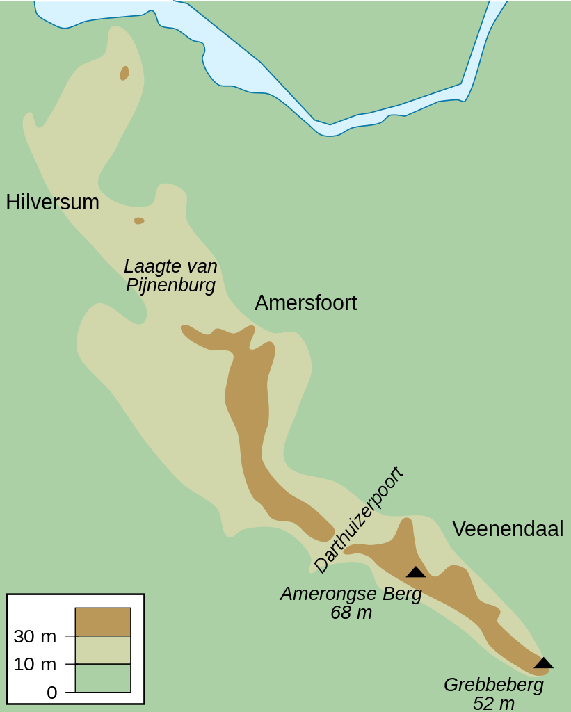
English: Map of the Utrecht Hill Ridge, a chain of hills located largely in the province of Utrecht, the Netherlands. The map shows the 10 m and 30 m contour lines, the two main peaks and the general location of several towns in the area.
Nederlands: Kaart van de Utrechtse Heuvelrug, grotendeels gelegen in de Nederlandse provincie Utrecht. De kaart toont de 10-meterlijn, de 30-meterlijn, de twee bekendste toppen en de ruwe locatie van een aantal naburige plaatsen. |
| Datum | |
| Brón | Eige werk |
| Sjriever | DennisM |
Licentie:
| Iech, de autäörsrechhöbbende vaan dit wirk, geef dit wirk vrij in 't publiek domein. Dit is wereldwijd vaan toupassing. In sommig len is dit wettelik neet meugelek; in die gevalle gelt: Ich staon ederein toe dit wirk veur ènnig doel te broeke, zónger ènnig veurwaerj, behauve zölk veurwaerj dóre wet waere veurgesjreve. |
Besjtandshistorie
Klik op 'ne datum/tied óm 't besjtand te zeen wie 't oetzaog op det tiedsjtip.
| Datum/Tied | Miniatuurplaetje | Aafmaetinge | Gebroeker | Kómmentaar | |
|---|---|---|---|---|---|
| hujig | 25 jul 2010 12:50 | | 485 × 605 (24 kB) | DennisM | {{Information |Description={{en|1=Map of the Utrecht Hill Ridge, a chain of hills located largely in the province of Utrecht, the Netherlands. The map shows the 10 m and 30 m contour lines, the two main peaks and the general location of several towns in t |
Plaetjesverwiezinge
Dit plaetje weurt op de volgende pazjena's gebroek:
Globaal besjtandjsgebroek
De volgende anger wiki's gebroeke dit bestandj:
- Gebroek in en.wikipedia.org
- Gebroek in fr.wikipedia.org
- Gebroek in fy.wikipedia.org
- Gebroek in nl.wikipedia.org
- Gebroek in sl.wikipedia.org
- Gebroek in www.wikidata.org