Plaetje:California map showing Ventura County.png
Gein hoeger resolutie besjikbaar.
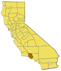
California_map_showing_Ventura_County.png ((200 × 231 pixel, besjtandsgruutde: 22 kB, MIME type: image/png))
- {{en|Map of Ventura County — in western Southern California.
From en:

|
Toesteumming wert verleend veur t kopiëre, verspreide en/of wiezige van dit document onger de veurwaerd van de GNU-licentie veur vrieje documentatie, versie 1.2 of einige latere versie es gepubliceerd door de Free Software Foundation; zonger Invariant Sections, zonger Front-Cover Texts, en zonger Back-Cover Texts. n kopie van de licentie is opgenomme in de sectie GNU-licentie veur vrieje documentatie. |
| Dit bestandj steit gelicenseerdj óngere Creative Commons Attribution-Share Alike 3.0 Unported lisensje. | ||
| ||
| Dees licentie-tag woort tougevoeg aon dit bestand in verband mèt de GFDL licentie-update. |
Besjtandshistorie
Klik op 'ne datum/tied óm 't besjtand te zeen wie 't oetzaog op det tiedsjtip.
| Datum/Tied | Miniatuurplaetje | Aafmaetinge | Gebroeker | Kómmentaar | |
|---|---|---|---|---|---|
| hujig | 14 jul 2005 17:32 | | 200 × 231 (22 kB) | Pyramide~commonswiki | Map of Ventura county in California. From en: {{GFDL}} Category:Maps of counties in California |
Plaetjesverwiezinge
Dit plaetje weurt op de volgende pazjena's gebroek:
Globaal besjtandjsgebroek
De volgende anger wiki's gebroeke dit bestandj:
- Gebroek in bg.wikipedia.org
- Gebroek in en.wikipedia.org
- Santa Clara River Valley
- Chatsworth Peak
- Topatopa Mountains
- Coyote Creek (Ventura County)
- Solimar Beach
- Template:VenturaCountyCA-geo-stub
- Frazier Mountain
- Simi Peak
- Sawmill Mountain
- Hidden Valley, Ventura County, California
- Upper Ojai, California
- Buckhorn, Ventura County, California
- Sea Cliff, California
- CSU Channel Islands University Park
- San Buenaventura State Beach
- Arroyo Sequit
- Mussel Shoals, California
- Santa Rosa Valley
- Lockwood Valley, California
- Cuddy Canyon, California
- Cobblestone Mountain (California)
- Sandstone Peak
- Triunfo Pass
- Ortonville, California
- Ojala, California
- Sespe Gorge
- Ventura County Superior Court
- Exchange Peak
- Hines Peak
- Tri Peaks (Santa Monica Mountains)
- Mugu Lagoon
- Knoll Open Space
- Fireworks Hill
- Dos Vientos, Thousand Oaks, California
- Camp Bartlett, California
- Calleguas Creek
- Lyons Hot Springs
- Arroyo Verde Park
- Gebroek in fa.wikipedia.org
- Gebroek in pam.wikipedia.org
- Gebroek in www.wikidata.org