Plaetje:California map showing Solano County.png
Gein hoeger resolutie besjikbaar.
California_map_showing_Solano_County.png ((200 × 231 pixel, besjtandsgruutde: 22 kB, MIME type: image/png))
Besjrieving
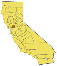
- Locator map of Solano County — in California.

|
Toesteumming wert verleend veur t kopiëre, verspreide en/of wiezige van dit document onger de veurwaerd van de GNU-licentie veur vrieje documentatie, versie 1.2 of einige latere versie es gepubliceerd door de Free Software Foundation; zonger Invariant Sections, zonger Front-Cover Texts, en zonger Back-Cover Texts. n kopie van de licentie is opgenomme in de sectie GNU-licentie veur vrieje documentatie. |
| Dit bestandj steit gelicenseerdj óngere Creative Commons Attribution-Share Alike 3.0 Unported lisensje. | ||
| ||
| Dees licentie-tag woort tougevoeg aon dit bestand in verband mèt de GFDL licentie-update. |
Besjtandshistorie
Klik op 'ne datum/tied óm 't besjtand te zeen wie 't oetzaog op det tiedsjtip.
| Datum/Tied | Miniatuurplaetje | Aafmaetinge | Gebroeker | Kómmentaar | |
|---|---|---|---|---|---|
| hujig | 14 jul 2005 17:28 | | 200 × 231 (22 kB) | Pyramide~commonswiki | Map of Solano county in California. From en: {{GFDL}} Category:Maps of counties in California |
Plaetjesverwiezinge
Dit plaetje weurt op de volgende pazjena's gebroek:
Globaal besjtandjsgebroek
De volgende anger wiki's gebroeke dit bestandj:
- Gebroek in bg.wikipedia.org
- Gebroek in en.wikipedia.org
- Cordelia, California
- Template:SolanoCountyCA-geo-stub
- Horse Creek (California)
- Hastings Mine
- St. John's Mine
- City Park, Benicia
- Rindler Creek
- Grizzly Bay
- Mare Island Strait
- Roe Island
- Ryer Island
- Ryer Island Ferry
- Rockville, California
- English Hills
- Potrero Hills (Solano County, California)
- Ryer Island (Suisun Bay)
- Batavia, California
- Howard Landing Ferry
- Morrow Island
- Tremont Township, Solano County, California
- Denverton, California
- Hammond Island (California)
- Dutton Island
- Freeman Island (California)
- Grizzly Island
- Simmons Island
- Snag Island
- Wheeler Island (California)
- Decker Island
- Prospect Island (California)
- Lynch Canyon Open Space Park
- French Island (California)
- Liberty Island (California)
- Hastings Tract
- Bradmoor Island
- Deadman Island (Solano County)
- Goat Island (Solano County)
- Middle Ground Island
- Spinner Island
- Little Island (California)
- Island No. 1
- Knight Island (California)
Bekiek wikiwied gebroek van dit bestandj.