Plaetje:Breakup of Yugoslavia.gif
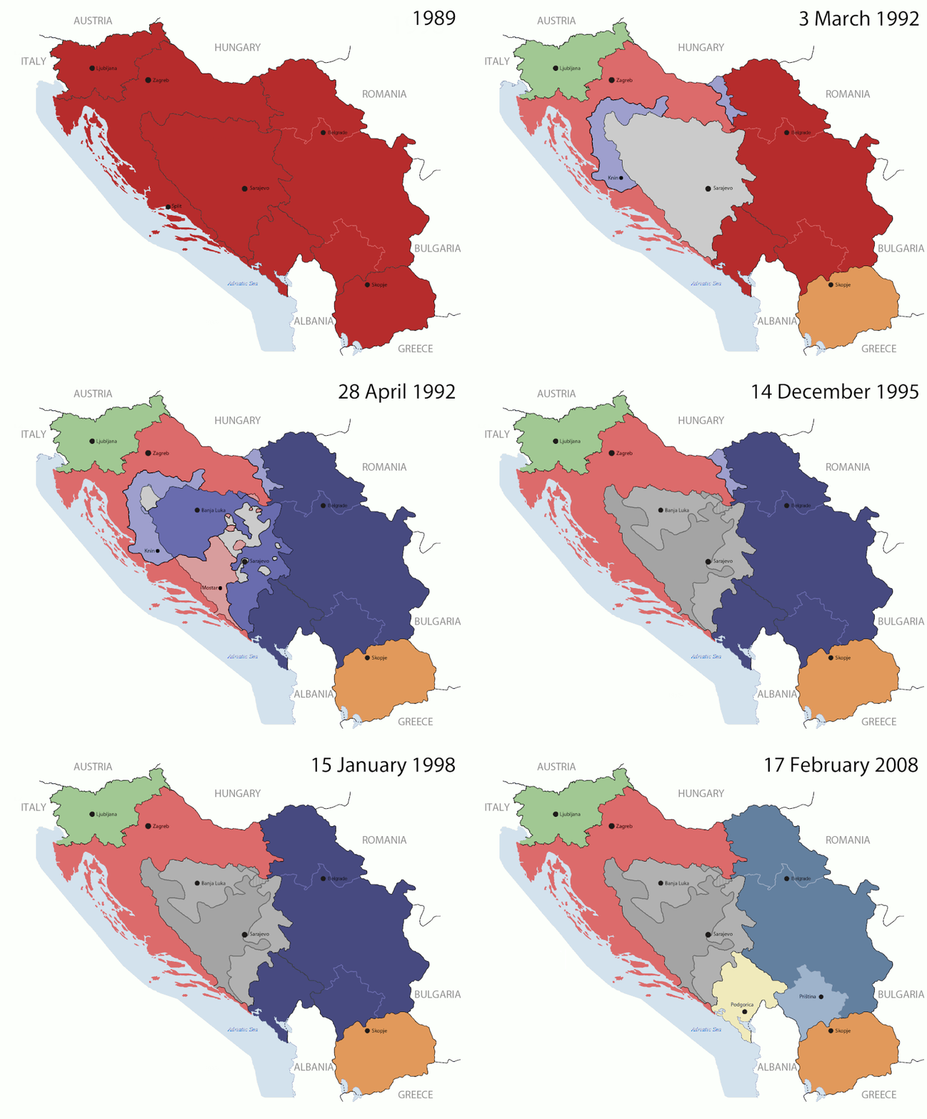
Oearsprunkelik bestandj((1.545 × 1.242 pixel, besjtandsgruutde: 187 kB, MIME type: image/gif), herhaolendj, 14 kadere, 44 s)

Dit besjtandj kump van Wikimedia Commons en kin ouch in anger projekte gebroek waere. De pagina mit de besjtandjsbesjrieving wurt hiejónger weergegaeve.

This image could be re-created using vector graphics as an SVG file. This has several advantages; see Commons:Media for cleanup for more information. If an SVG form of this image is available, please upload it and afterwards replace this template with {{vector version available|new image name}}. It is recommended to name the SVG file "Breakup of Yugoslavia.svg" - then the template Vector version available (or Vva) does not need the new image name parameter.

Besjrieving

Key:

Yugoslavia (1943–1992) SFR Yugoslavia
Croatia (1991–present) Croatia
Herzeg-Bosnia (1992–1994)
UNTAES (1996–1998)
Federal Republic of Yugoslavia / Serbia and Montenegro (1992–2006) Serbia and Montenegro
Republika Srpska (1992–present) Republika Srpska
Serbian Krajina (1991–1995/96)
Republic of Bosnia and Herzegovina (1992–1995)
Bosnia and Herzegovina (1998–present) Bosnia and Herzegovina
Western Bosnia (1993–1995)
Serbia (2006–present) Serbia
Kosovo (under UNMIK control 1999–present; declaration of independence 2008) Kosovo
Montenegro (2006–present) Montenegro
Macedonia (1991–present) Macedonia
Slovenia (1991–present) Slovenia


Besjrieving

This is an animated GIF that shows the stages of the breakup of the SFR Yugoslavia in the 90's and 2000's. The map based off Morwen's map of the divisions of the SFRY, Which is licensed by the GFDL. The source for the dates of independence is the CIA World Factbook. These maps do not now show the Inter-Entity Boundary Line (IEBL) and/or the entities that are separated by it. The IEBL has been drawn based on this CIA map; the Brčko District has been drawn based on Image:BH municipality location.gif, by user:Ante Perkovic. I might add them in the future.

Since the original map was GFDL, this image is as well.

A map depicting Kosovo's final status is ready once it takes effect.


Changelog for versions 2/3:

Here are some changes in this new build of the map:

  • The Kosovo boundary has been given a shade of red instead of the previous UN blue since they are a province of Serbia under UNIMIK control.
  • Montenegro's color has been changed to a golden shade close to what's on the flag.
  • The IEBL and the Brčko District has been redrawn because I deleted the original map; the color for the Republika Srpska is lighter.
  • The dates are at the top left hand corner of the map instead of the bottom.
  • I have taken a new approach as to the boundaries. Each part of Yugoslavia now shows the boundary on the maps starting the year they broke away. I feel this change helps readers understand the breakup better.
  • The SFRY and the FRY are in different shades since the FRY was never accepted as the successor to the former by the UN.
  • The colors for the entities of BiH have been removed as to not confuse people into thinking that they are independent states. What remains is the IEBL with both entities in green.
  • The Kosovo boundary is finally in hash marks!
  • The Brčko District has been removed. The sale is too small to show accurately.

Changelog for version 4:

  • The map is larger!
  • The image has been rebuilt to include the eastern part of FYR Macedonia.
  • The image has been updated to take in Kosovo's new status.
  • The IEBL is now a darker line.
  • Montenegro, Kosovo, and FRY/SCG/Serbia have new colors!

Changelog for version 5:

  • Rebuilt
  • Larger map: size of base image
  • Accurate Inter-Entity Boundary Line
Datum 24 July 2006 (orginal upload date)
Brón Made by Hoshie; see above for more details on sources.
Sjriever Hoshie
Anger versies

Licentie:

GNU head Toesteumming wert verleend veur t kopiëre, verspreide en/of wiezige van dit document onger de veurwaerd van de GNU-licentie veur vrieje documentatie, versie 1.2 of einige latere versie es gepubliceerd door de Free Software Foundation; zonger Invariant Sections, zonger Front-Cover Texts, en zonger Back-Cover Texts. n kopie van de licentie is opgenomme in de sectie GNU-licentie veur vrieje documentatie.
w:nl:Creative Commons
Attribuusje Deil gliek
Dit bestandj steit gelicenseerdj óngere Creative Commons Attribution-Share Alike 3.0 Unported lisensje.
De maags:
  • deile – aafsjrieve, verspreie en dórchgaeve
  • hèrminge – 't wèrk aanpasje
Óngere volgendje veurwaerj:
  • Attribuusje – Geer mótj op 'n gepasdje meneer 'n naamsvermeljing make, 'ne link nao de licentie opgaeve, en aangaeve of g'r 't werk verangerd höb. Geer moog dit op eder raejelike meneer doon, meh neet zoea det 't liek ofwen de licentiegaever instump mit eur werk of eur gebroek van zie werk.
  • Deil gliek – Went geer dit werk geremix, verangerd of doorverwirk höb, mótj geer 't verangerd matterjaal verspreie ónger dezelfde licentie wie 't oersjprunkelik werk, of 'n licentie die daomit samegeit.
Dees licentie-tag woort tougevoeg aon dit bestand in verband mèt de GFDL licentie-update.

Bijschriften

Beschrijf in één regel wat dit bestand voorstelt

Items getoond in dit bestand

beeldt af Nederlands

maker Nederlands

Waarde zonder Wikidata-item

MIME-type Nederlands

image/gif

checksum Nederlands

05ca2aefea8406b809968643552d5095c847a42f

methode van vaststelling Nederlands: SHA-1 Nederlands

datagrootte Nederlands

191.625 byte

tijdsduur Nederlands

44 secónd

hoogte Nederlands

1.242 pixel

breedte Nederlands

1.545 pixel

Besjtandshistorie

Klik op 'ne datum/tied óm 't besjtand te zeen wie 't oetzaog op det tiedsjtip.

(nuujste | aadste) (nujer 10) () (10 | 20 | 50 | 100 | 250 | 500) bekieke.
Datum/TiedMiniatuurplaetjeAafmaetingeGebroekerKómmentaar
hujig17 jul 2016 09:40Miniatuurplaetje veur versie per 17 jul 2016 09:401.545 × 1.242 (187 kB)מפתח-רשימהReverted to version as of 17:22, 21 August 2015 (UTC)
21 aug 2015 19:22Miniatuurplaetje veur versie per 21 aug 2015 19:221.463 × 1.158 (1,81 MB)BraganzaReverted to version as of 03:57, 19 January 2010
21 aug 2015 19:22Miniatuurplaetje veur versie per 21 aug 2015 19:221.545 × 1.242 (187 kB)BraganzaReverted to version as of 01:02, 19 December 2011
21 aug 2015 19:15Miniatuurplaetje veur versie per 21 aug 2015 19:15120 × 95 (3 kB)Braganza03:57, 19. Jan. 2010
19 dec 2011 03:02Miniatuurplaetje veur versie per 19 dec 2011 03:021.545 × 1.242 (187 kB)DIREKTORAdded details
27 jul 2011 20:09Miniatuurplaetje veur versie per 27 jul 2011 20:091.545 × 1.242 (170 kB)DIREKTORSmall fixes
27 jul 2011 19:28Miniatuurplaetje veur versie per 27 jul 2011 19:281.545 × 1.242 (171 kB)DIREKTORAdded UNMIK
27 jul 2011 18:38Miniatuurplaetje veur versie per 27 jul 2011 18:381.545 × 1.242 (165 kB)DIREKTORDates for the last two frames.
27 jul 2011 14:10Miniatuurplaetje veur versie per 27 jul 2011 14:101.545 × 1.242 (149 kB)DIREKTORLighter shade for country names
26 jul 2011 18:59Miniatuurplaetje veur versie per 26 jul 2011 18:591.545 × 1.242 (170 kB)DIREKTORHigher res plus details
(nuujste | aadste) (nujer 10) () (10 | 20 | 50 | 100 | 250 | 500) bekieke.

Dit plaetje weurt op de volgende pazjena's gebroek:

Globaal besjtandjsgebroek

De volgende anger wiki's gebroeke dit bestandj:

Bekiek wikiwied gebroek van dit bestandj.

Metadata

Aafkomstig van Wikipedia, de Vriej Encyclopedie. "https://li.wikipedia.org/wiki/Plaetje:Breakup_of_Yugoslavia.gif"