Plaetje:Bokhoven-Blaeu-1665.jpg

Gruutde van dees veurvertuining: 528 × 600 pixels. Anger resoluties: 211 × 240 pixels | 423 × 480 pixels | 678 × 770 pixels.
Oearsprunkelik bestandj ((678 × 770 pixel, besjtandsgruutde: 349 kB, MIME type: image/jpeg))
Besjrieving
| Besjrieving |
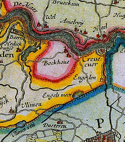
English: Map of the lordship of Bokhoven
Nederlands: kaart van de heerlijkheid Bokhoven |
||||||||||||||||||||||||||
| Datum | |||||||||||||||||||||||||||
| Brón | Atlas Maior | ||||||||||||||||||||||||||
| Sjriever |
|
||||||||||||||||||||||||||
.jpg)
Licentie:
|
Dit werk bevindt zich in het publiek domein in landen en gebieden waar de auteursrechttermijn het leven van de auteur plus 100 jaar of minder is. | |
| Van dit bestandj is vasgesteld det t'r gein bekindje sjrieversaansprake op ruste, inbegrepe van anger kórtbie rechte. | |
Besjtandshistorie
Klik op 'ne datum/tied óm 't besjtand te zeen wie 't oetzaog op det tiedsjtip.
| Datum/Tied | Miniatuurplaetje | Aafmaetinge | Gebroeker | Kómmentaar | |
|---|---|---|---|---|---|
| hujig | 11 dec 2010 22:01 | | 678 × 770 (349 kB) | Joostik | {{Information |Description={{en|1=Map of the lordship of Bokhoven}} {{nl|1=kaart van de heerlijkheid Bokhoven}} |Source=Atlas Maior |Author=Joan Blaeu |Date=1665 |Permission= |other_versions= }} Category:Maps of the Netherlands |
Plaetjesverwiezinge
Dit plaetje weurt op de volgende pazjena's gebroek:
Globaal besjtandjsgebroek
De volgende anger wiki's gebroeke dit bestandj:
- Gebroek in nl.wikipedia.org
- Gebroek in www.wikidata.org