Plaetje:2022 East Timor municipalities numbers.png

Gruutde van dees veurvertuining: 800 × 461 pixels. Anger resoluties: 320 × 185 pixels | 640 × 369 pixels | 1.024 × 591 pixels | 1.280 × 738 pixels | 3.344 × 1.929 pixels.
Oearsprunkelik bestandj ((3.344 × 1.929 pixel, besjtandsgruutde: 222 kB, MIME type: image/png))
Besjrieving
| Besjrieving |
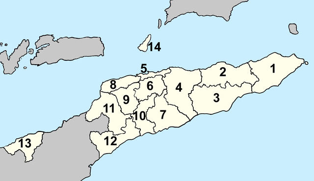
Deutsch: Lagekarte der Gemeinden Osttimors (nummeriert) seit 2022 English: Locator map of municipalities of East Timor (numbered) since 2022 |
| Datum | |
| Brón | Eige werk |
| Sjriever | Patrick |
Licentie:
Ich, de kopierechhaajer hievan, bring 't hiebie óngere vólgendje lisensje oet:

|
Toesteumming wert verleend veur t kopiëre, verspreide en/of wiezige van dit document onger de veurwaerd van de GNU-licentie veur vrieje documentatie, versie 1.2 of einige latere versie es gepubliceerd door de Free Software Foundation; zonger Invariant Sections, zonger Front-Cover Texts, en zonger Back-Cover Texts. n kopie van de licentie is opgenomme in de sectie GNU-licentie veur vrieje documentatie. |
Dit bestand is gelicenseerd onder de Creative Commons Naamsvermelding 4.0 Internationaal licentie.
- De maags:
- deile – aafsjrieve, verspreie en dórchgaeve
- hèrminge – 't wèrk aanpasje
- Óngere volgendje veurwaerj:
- Attribuusje – Geer mótj op 'n gepasdje meneer 'n naamsvermeljing make, 'ne link nao de licentie opgaeve, en aangaeve of g'r 't werk verangerd höb. Geer moog dit op eder raejelike meneer doon, meh neet zoea det 't liek ofwen de licentiegaever instump mit eur werk of eur gebroek van zie werk.
De kens zelf de lisensje oetkeze.
Besjtandshistorie
Klik op 'ne datum/tied óm 't besjtand te zeen wie 't oetzaog op det tiedsjtip.
| Datum/Tied | Miniatuurplaetje | Aafmaetinge | Gebroeker | Kómmentaar | |
|---|---|---|---|---|---|
| hujig | 4 apr 2022 20:48 | | 3.344 × 1.929 (222 kB) | J. Patrick Fischer | {{Information |Description={{de|Lagekarte der Gemeinden Osttimors (nummeriert) seit 2022}} {{en|Locator map of municipalities of East Timor (numbered) since 2022}} |Source={{own}} |Date=2022-04-04 |Author=Patrick |Permission= |other_versions= }} == {{int:license-header}} == {{self|GFDL|cc-by-4.0}} Category:Maps of municipalities of East Timor Category:Maps of Subdivisions of East Timor Category:Images by J. Patrick Fischer |
Plaetjesverwiezinge
Dit plaetje weurt op de volgende pazjena's gebroek:
Globaal besjtandjsgebroek
De volgende anger wiki's gebroeke dit bestandj:
- Gebroek in de.wikipedia.org
- Gebroek in eo.wikipedia.org
- Gebroek in fa.wikipedia.org
- Gebroek in gl.wikipedia.org
- Gebroek in he.wikipedia.org
- Gebroek in id.wikipedia.org
- Gebroek in ja.wikipedia.org
- Gebroek in lt.wikipedia.org
- Gebroek in ms.wikipedia.org
- Gebroek in nl.wikipedia.org
- Gebroek in pl.wikipedia.org
- Gebroek in pt.wikipedia.org
- Gebroek in tet.wikipedia.org
- Gebroek in tr.wikipedia.org
- Gebroek in uk.wikipedia.org
- Gebroek in vi.wikipedia.org
- Gebroek in zh-classical.wikipedia.org
- Gebroek in zh.wikipedia.org