Plaetje:Åland Political Map-en.svg

Aafmaetinge van dees veurbesjoewing van 't type PNG van dit SVG-bestandj: 595 × 600 pixels Anger resoluties: 238 × 240 pixels | 476 × 480 pixels | 762 × 768 pixels | 1.016 × 1.024 pixels | 2.032 × 2.048 pixels | 996 × 1.004 pixels.
Oearsprunkelik bestandj (SVG-bestandj, nominaal 996 × 1.004 pixels, bestandsgruutde: 219 kB)
Besjrieving
| Besjrieving |
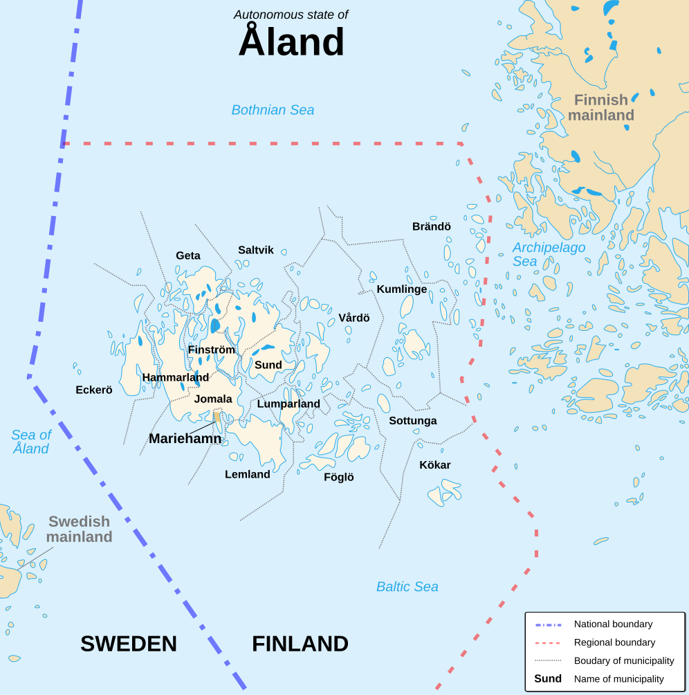
English: Political map of the autonomous finnish province of Åland, in english. Shows the national, regional and municipal boundaries about Åland islands. Français : Carte politique de l'État libre associé d'Åland, en anglais. La carte montre les frontières internationales, régionales et municipales concernant l'archipel d'Åland. |
||
| Datum | |||
| Brón |
English: Image:Alandmunicipalities.png and Image:Åland map.png, from Demis (see the approval e-mail and Demis forum). Français : Image:Alandmunicipalities.png et Image:Åland map.png, elles-même basées sur le site internet de Demis (voir le courriel d'autorisation et le forum de Demis). |
||
| Sjriever | Sémhur (talk) | ||
| Anger versies |
|
||
| Attribuusje (required by the license) | © Sémhur / Wikimedia Commons / | ||
| SVG | W3C-validity not checked. Deze niet W3C-verklaarde vectorafbeelding is gemaakt met Inkscape .
|
||
| Atelier graphique |

| Cameralocatie | | Deze en andere afbeeldingen in: OpenStreetMap |
|---|
Licentie:
Ich, de kopierechhaajer hievan, bring 't hiebie óngere vólgendje lisensje oet:
| Copyleft: dit kunswerk is vrie; de maags t heroetgaeven en/of wiezigen in euvereinkoms mitte veurwaerd van de Free Art-licentie.
De kins e veurbeildj van de licentie vinjen op de website van Copyleft Attitude zouch op anger websites. |
This file is licensed under the Creative Commons Attribution-Share Alike 4.0 International, 3.0 Unported, 2.5 Generic, 2.0 Generic and 1.0 Generic license.
- De maags:
- deile – aafsjrieve, verspreie en dórchgaeve
- hèrminge – 't wèrk aanpasje
- Óngere volgendje veurwaerj:
- Attribuusje – Geer mótj op 'n gepasdje meneer 'n naamsvermeljing make, 'ne link nao de licentie opgaeve, en aangaeve of g'r 't werk verangerd höb. Geer moog dit op eder raejelike meneer doon, meh neet zoea det 't liek ofwen de licentiegaever instump mit eur werk of eur gebroek van zie werk.
- Deil gliek – Went geer dit werk geremix, verangerd of doorverwirk höb, mótj geer 't verangerd matterjaal verspreie ónger dezelfde licentie wie 't oersjprunkelik werk, of 'n licentie die daomit samegeit.
De kens zelf de lisensje oetkeze.
Besjtandshistorie
Klik op 'ne datum/tied óm 't besjtand te zeen wie 't oetzaog op det tiedsjtip.
| Datum/Tied | Miniatuurplaetje | Aafmaetinge | Gebroeker | Kómmentaar | |
|---|---|---|---|---|---|
| hujig | 21 aug 2007 18:11 | | 996 × 1.004 (219 kB) | Sémhur | {{Information |Description=Political map of the autonomous finnish province of Åland, in english.<br/> Shows the national, regional and municipal boundaries about Åland islands. |Source=Own work. Based on Image:Alandmunicipalities.png and [[:Image: |
Plaetjesverwiezinge
Dit plaetje weurt op de volgende pazjena's gebroek:
Globaal besjtandjsgebroek
De volgende anger wiki's gebroeke dit bestandj:
- Gebroek in ca.wikipedia.org
- Gebroek in en.wikipedia.org
- Gebroek in es.wikipedia.org
- Gebroek in ga.wikipedia.org
- Gebroek in gl.wikipedia.org
- Gebroek in hy.wikipedia.org
- Gebroek in nl.wikipedia.org
- Gebroek in ru.wikipedia.org
- Gebroek in www.wikidata.org