Plaetje:Arrondissement Nivelles Belgium Map.png
Gein hoeger resolutie besjikbaar.
Arrondissement_Nivelles_Belgium_Map.png ((190 × 95 pixel, besjtandsgruutde: 2 kB, MIME type: image/png))
Besjrieving
| Besjrieving |
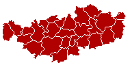
English: This map indicates (in red) the location of administrative and judicial arrondissements of Nivelles in the province of Brabant Wallon, Belgium. Both maps are the same and fill all the province of Brabant Wallon. In this case, a redirection is available at File:Judicial_Arrondissement_Nivelles_Belgium_Map.png for an easy and intuitive access to judicial arrondissement map. Colors changed based on work from w:nl:Gebruiker:LennartBolks/kaartenhoekje also in PD
Français : Cette carte indique (en rouge) la localisation de l'arrondissement administratif et judiciaire de Nivelles dans la Province de Brabant wallon, Belgique. Les deux cartes se confondent et occupent toute la province du Brabant wallon. De cette manière, une redirection est accessible à File:Judicial_Arrondissement_Nivelles_Belgium_Map.png pour un accès facile et intuitif à la carte de l'arrondissement judiciaire. Les couleurs sont basées sur le travail de w:nl:Gebruiker:LennartBolks/kaartenhoekje. |
| Brón | Eige werk |
| Sjriever | LennartBolks |
Licentie:
| Dit wirk vrijgegeve in 't publiek domein door de autäör, LennartBolks. Dit is wereldwijd vaan toupassing. In sommig len is dit wettelik neet meugelek; in die gevalle gelt: |
Besjtandshistorie
Klik op 'ne datum/tied óm 't besjtand te zeen wie 't oetzaog op det tiedsjtip.
| Datum/Tied | Miniatuurplaetje | Aafmaetinge | Gebroeker | Kómmentaar | |
|---|---|---|---|---|---|
| hujig | 2 apr 2005 11:27 | | 190 × 95 (2 kB) | Nicnac25~commonswiki | Map of Nivelles District in province of Brabant Wallon, Belgium FR; Carte indiquant la localisation de l'arrondissement de Nivelles dans la Province de Brabant wallon. {{PD}} colors changed by me, based on work from [[w:nl:Gebruiker:LennartBolks/kaartenh |
Plaetjesverwiezinge
Dit plaetje weurt op de volgende pazjena's gebroek:
Globaal besjtandjsgebroek
De volgende anger wiki's gebroeke dit bestandj:
- Gebroek in bg.wikipedia.org
- Gebroek in br.wikipedia.org
- Gebroek in bs.wikipedia.org
- Gebroek in ceb.wikipedia.org
- Gebroek in cs.wikipedia.org
- Gebroek in de.wikipedia.org
- Gebroek in de.wikivoyage.org
- Gebroek in fa.wikipedia.org
- Gebroek in fr.wikipedia.org
- Gebroek in gl.wikipedia.org
- Gebroek in hu.wikipedia.org
- Gebroek in it.wikipedia.org
- Gebroek in lb.wikipedia.org
- Gebroek in lv.wikipedia.org
- Gebroek in nl.wikipedia.org
- Gebroek in no.wikipedia.org
- Gebroek in ru.wikipedia.org
- Gebroek in sv.wikipedia.org
- Gebroek in th.wikipedia.org
- Gebroek in vec.wikipedia.org
- Gebroek in vi.wikipedia.org
- Gebroek in vls.wikipedia.org
- Gebroek in wa.wikipedia.org